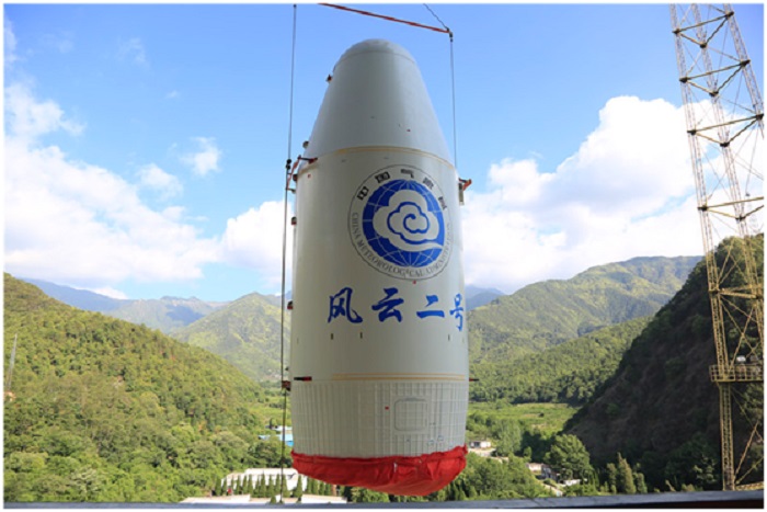


China’s Fengyun meteorological satellite family is providing services for users in 121 countries and regions around the world, including 85 countries and regions along the routes of the Belt and Road Initiative (BRI), said the China Meteorological Administration (CMA).
More than 1,400 people in 92 countries and regions in the world have received training in technologies related to the meteorological satellite family, according to the CMA.
Providing users at home and abroad with free access to data in real time, the Fengyun satellites have played an important role in weather forecast, natural disaster response, and ecological and environmental governance in relevant countries and regions as well as the world at large.
Data released by the CMA on Dec. 13 showed that since it was put into operation in January 2019, China’s Fengyun-2H meteorological satellite, which is dubbed “the Belt and Road satellite”, has provided a total of 55,000 cloud images, with 28 full-disk cloud images and 20 images of clouds in the northern hemisphere on a daily basis.
They have been widely used in weather monitoring and forecasting, disaster warning, agricultural production, scientific research and other fields in countries and regions along the routes of the BRI.
After its setpoint position in space was shifted westward, the Fengyun-2H meteorological satellite has made up for the blind spots of global meteorological satellites in regions including the Indian Ocean, Central and West Asia, and Africa and been able to better serve BRI countries and regions.
Its over 50,000 cloud images have been widely used in the response to natural disasters such as tropical cyclones in the Arabian Sea and floods in Sri Lanka, a vivid proof that China keeps its solemn promise to provide meteorological services to all parties with its Fengyun-2 weather satellites.
Data collected by the Fengyun-2H geostationary orbit satellite, which includes images of different channels of the Fengyun-2H satellite and products like cloud top temperature and cloud classification, helps Namibia’s meteorological authority with daily weather prediction, said Vilho Ndeunyema, weatherman with Namibia Meteorological Service, at the 2021 Fengyun Satellite User Conference held last month.
According to Ndeunyema, Chinese technical engineers have assisted Namibia Meteorological Service in the installation and application of Fengyun-3 Polar-orbiting Satellite Data Receiving and Processing System, which receives real-time data of Fengyun-3 satellites and other international satellites.
Such data is then processed to generate relevant products in environmental monitoring services, including vegetation and lake monitoring, effectively enhancing the capability of Namibia Meteorological Service to provide environmental monitoring services, which is critical to Namibia, a country long plagued by perennial drought, said Ndeunyema.
In fact, besides Fengyun-2H, all the other members of China’s Fengyun meteorological satellite family are also providing services for the weather forecast, natural disaster response, and ecological and environmental governance of countries and regions along the routes of the BRI and even the entire world, which has been troubled by global warming and increasingly frequent extreme weather events.
Fengyun-3E, the world’s first meteorological satellite in dawn-dusk orbit for civil service, which is still in its in-orbit testing stage, as well as China’s new-generation meteorological satellite in geostationary orbit, Fengyun-4B, both sent into space by China several months ago, have even received request for services from global users before they are officially put into operation.
On June 6 and 7 this year, Sri Lanka sought assistance from China because of flooding caused by rainstorms and an oil spill from a cargo vessel, asking the latter to initiate the Emergency Support Mechanism for International Users of FengYun Meteorological Satellites in Disaster Prevention and Mitigation. It then got dedicated emergency data and monitoring and analysis report from Fengyun satellites for coping with its crises.
“We initiated the mechanism for more than 20 times this year to help countries including Sri Lanka, Bangladesh, Myanmar, and Nepal respond to disasters like dam break, volcanic eruption, and heavy rainfall,” said Wang Jingsong, director-general of the National Satellite Meteorological Center under the CMA.
China is trying to make its Fengyun-4A, Fengyun-3D, and Fengyun-2H meteorological satellites listed among the “satellites on duty” of the International Charter: Space and Major Disasters to integrate into the international emergency response mechanism, Wang noted.
“In fact, our data services, information receiving platform, remote sensing application products and skills training are all offered to users for free. Global users and Chinese users are all treated as equals in terms of data acquisition,” said Xian Di, deputy head of the remote sensing application center of the CMA.
Data collected by China’s Fengyun meteorological satellites has been used more and more in Europe and the U.S. as well as other developed countries in such fields as data assimilation, short and imminent precipitation forecast, marine monitoring as well as scientific research.
In 2021, global users of Fengyun satellites made more than 2,000 orders for data services and downloaded over nine million data files, getting more than 60TB of data.
China plans to send another five meteorological satellites into space during its 14th Five Year Plan period (2021-2025), and completely replace the current Fengyun meteorological satellites with the third-generation comprehensive meteorological satellite observation system by 2035.


The Executive and members of the.


The Acting Director, FCT Directorate of.


President Bola Ahmed Tinubu has been.


Barely a month after resignation of.


An Abuja based Legal Practitioner, Osuagwu.


Convener of Equitable Remedy, Mrs. Magaret.


Contractors handling the contract for city.


Nigerian government may have concluded plans.


The Diplomatic Correspondents Association of Nigeria.


A rights group, “Follow Me Talk.
Leave a Comment